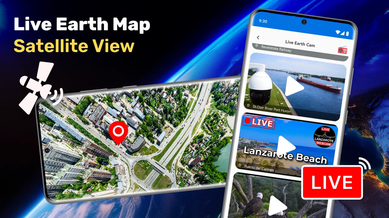
Live Earth Map Satellite View
- 3.8
- Rating
- 1.00M
- Installs
- Free
- Price
 Analysis by App-foxy
I opened Live Earth Map Satellite View expecting a simple way to look around the planet, and that is still the best way to understand it: this is a free Android maps and navigation app built around visual exploration rather than turn-by-turn driving. Its appeal comes from seeing the world as a broad, interactive map, then moving between familiar places and less familiar ones with a more visual approach than a conventional street-navigation tool.
That distinction matters. I would not install it as my only navigation solution for a long drive, but I can see why someone would keep it for browsing cities, checking the shape of mountain regions, or getting a quick geographic sense of a place before visiting. Galaxy studio apps presents it as a live Earth map with a three-dimensional world view, and in everyday use I found that concept more useful for orientation and curiosity than for precise route planning.
How the current app feels in everyday use
The current release is version 18.0.1, and the app has been available since March 6, 2022. That gives it a reasonably established presence rather than the feel of a brand-new experiment. It has passed one million installs and holds a 4.0 average from around 7.8 thousand ratings, so there is a sizeable audience trying the same basic experience. I read those figures as a sign of practical appeal, but not as proof that it will replace the map app already on your phone.
You May Also Like

 Blood Strike: 2.5 Anniversary
Blood Strike’s Loadouts Turn Every Drop Into a Tactical Gamble
A close look at Blood Strike’s custom loadouts: how fast access to signature weapons reshapes its battle royale rhythm, rewards preparation, and narrows the gap between fights.

 Pandora - Music & Podcasts
Pandora’s Music Is Easy to Start, but Harder to Recover
Pandora’s strength is its low-effort path from a seed to a station. Its weak spot is how much confidence it asks you to place in connection, setup, and quiet recovery.

 8 Ball Pool
 Is Built on Rivalries, Rematches, and Routine
A close look at the rivalries, rematches, shared routines, and unanswered safety questions that turn a quick pool match into a persistent mobile community.

 Samsung Music
’s Quiet Strength Is Playing What You Already Own
Its reach comes less from spectacle than from dependable access to a personal library. That simplicity is both the app’s strongest retention engine and its ceiling.

 AccuWeather: Weather Radar
AccuWeather Review: A Quick, Clear Forecast for Everyday Decisions
For everyday plans, the best forecast is the one you can understand quickly. AccuWeather makes rain timing, radar, and local conditions easy to act on, with a few trade-offs.

 Hill Climb Racing
Why Hill Climb Racing Still Turns Crashes Into One More Run
A tiny car, a bumpy hill and one more upgrade: Hill Climb Racing keeps resurfacing because its simple chaos makes every near-miss feel personal.
More From Our News Desk



The first useful habit is to treat the globe view as an overview layer. I like starting with a broad location, rotating or moving across the map, and only then narrowing my attention to a city, coastline, mountain area, or recognizable landmark. That workflow is less efficient than typing an address into a standard navigation app, but it gives me a better mental picture of where a place sits in relation to surrounding terrain.
For example, before planning a weekend visit, I can inspect the destination from a wider geographic perspective, look at nearby cities, and notice whether the area is surrounded by hills, open land, or dense urban development. I would still verify roads, opening hours, traffic, and walking directions elsewhere. The value here is the visual context, not the final logistical answer.
The three-dimensional presentation also changes how I explore. A flat map is excellent when I already know what I am looking for, while a globe-style interface encourages me to zoom out, move across regions, and compare places. That makes the app pleasant for students, travelers who enjoy planning visually, and anyone who wants a quick geographic tour without opening a desktop globe application.
Exploration is the strongest reason to keep it installed
I found the app most convincing when I used it without a strict destination in mind. Searching for a city and then pulling back to see its surroundings feels more informative than jumping directly between isolated map pins. Mountains and large geographic features become easier to understand when they are viewed as part of a larger landscape rather than as a name on a list.
This is also where the app feels different from the usual alternatives. Google Maps, Apple Maps, and dedicated navigation tools are generally better when I need live traffic, a dependable route, business information, public transport details, or walking instructions. Live Earth Map Satellite View has a narrower identity: it is a visual map browser with a world-exploration angle. If that is what I want, the narrower focus is an advantage rather than a flaw.
There is a useful trade-off in that simplicity. I spend less time managing a route and more time understanding a place. On the other hand, I may need to switch to another app for the very next question, such as which road is fastest or whether a destination is open. Users who expect one application to handle discovery, navigation, local search, and trip logistics may find the experience incomplete.
What the version and release history tell me
The release date and current version provide helpful context, but they do not automatically tell me that every part of the experience has been transformed recently. I see version 18.0.1 as evidence that the app has continued along its product path since its original launch, not as a reason to assume a particular new feature or redesign. That is important when deciding whether to return after an update: I would judge the current interface and performance directly rather than expecting a completely different product.
For an existing user, a later version can be reassuring because it suggests the app remains actively maintained enough to have reached its present release. Still, the core reason to use it remains the same visual Earth-map concept. If you installed an earlier version specifically for globe browsing, the current edition should be evaluated on how comfortably it supports that habit, not on whether it has become a full substitute for established navigation platforms.
I also appreciate that the app is free to download. That lowers the barrier to testing it during a trip-planning session or for casual geographic exploration. There are in-app purchases ranging from $0.99 to $99.99 per item, however, so I would pay attention to any purchase screen and make sure I understand what is being offered before confirming anything. The free entry point is useful, but it should not be confused with every possible part of the experience being cost-free.
A practical workflow for travelers and students
My preferred workflow begins before I need directions. I search for the destination, zoom out until nearby geographic features become visible, and compare the place with the surrounding region. Then I make a short note of the landmarks or areas I want to investigate further. Only after that do I move to a specialist navigation app for routes and current travel conditions.
This two-step method avoids one of the most common mistakes with visual map apps: asking them to answer a question they were not designed to answer. The Earth view helps me form a picture; a navigation service helps me act on it. Used together, they are more practical than forcing either one to do everything.
For students, I would use it as a starting point for geography assignments or personal research. A learner can move from a country to a city, then examine how terrain and urban areas relate spatially. It is more engaging than reading a place name in isolation. I would still cross-check factual details with educational or official sources, especially for schoolwork, because a visually impressive map should not be treated as the sole authority for every geographic claim.
For travelers, the app can help answer a different question from “How do I get there?” It can answer “What does this destination look like in its wider setting?” That is particularly handy when choosing between areas that seem close on a list but are separated by notable terrain or a large urban spread.
Where the experience becomes less convenient
The same visual emphasis that makes browsing enjoyable can create friction when I have a precise task. If I already know an exact address and simply need the quickest route, opening a dedicated navigation app is usually faster. A conventional map service also tends to provide a richer layer of everyday decision-making tools, such as local listings and route alternatives. I would not choose this app for urgent navigation, unfamiliar driving, or situations where a missed turn would be costly.
There is another practical limitation: visual exploration can encourage me to spend time looking without reaching a clear answer. That is enjoyable when I am curious, but inefficient when I am late. I recommend deciding what you want from the session before opening it. A five-minute “understand the area” session is productive; an unplanned search can easily become a tour of unrelated places.
Phone size also affects the experience. On a larger screen, a broad map view is easier to interpret because more surrounding geography remains visible. On a smaller display, repeated zooming and panning may feel cramped, especially when I am trying to compare a city with distant terrain. That does not make the app unusable, but it does make it more suitable for relaxed exploration than for hurried decisions.
I would also keep expectations realistic around the word “live.” In ordinary conversation, it can suggest constantly refreshed imagery or real-time conditions. I would not use the app as my only source for current traffic, weather, road closures, or rapidly changing events. For those needs, I would open a service built specifically around live operational information and use this app for geographic viewing.
Who should try it, and who should skip it
I recommend it to people who enjoy visual maps, want to inspect cities and natural features from a global perspective, or prefer to understand a destination before dealing with routes. It is also a reasonable low-commitment download for someone who wants to explore a globe-style interface without paying an upfront price. The Everyone age rating makes it suitable for a broad audience, including families looking for a simple geography exploration tool.
I would be more cautious about recommending it to commuters, delivery drivers, hikers who require dependable route information, or anyone who needs detailed local navigation as the main purpose. Those users should start with a mature navigation service and add this app only if its visual world view offers something extra. The distinction is straightforward: use it to see and explore, not as the sole tool for time-sensitive movement.
It is also not the best choice if you dislike switching between apps. My own travel workflow often involves moving from the globe view to a route planner and then, if necessary, to an official source for destination details. That is perfectly manageable, but users who want a single comprehensive dashboard may prefer a more established all-in-one mapping platform.
Small habits that make it more useful
One tip is to begin wide and narrow gradually. Starting with an extremely close view can hide the geographic relationship that makes the app valuable. I get more from it when I first locate the broader region, then move toward the city or feature I care about. This also reduces the chance of confusing two places with similar names.
A second tip is to use it during planning, not while already under pressure. Before leaving, I can inspect the destination and build a mental reference for nearby areas. Once I am on the road, I switch to a navigation tool for current instructions. Separating those tasks makes the app feel purposeful instead of disappointing.
A third insight is to compare visual impressions with practical maps rather than assuming they are interchangeable. A mountain range that looks close on a globe may still involve difficult roads, restricted access, or a long travel time. The app is excellent at prompting questions; it is not a substitute for checking the details that determine whether a plan is realistic.
A fourth useful approach is to use it as a conversation tool. When explaining where a city sits or why a destination feels remote, a visual map can communicate the relationship faster than verbal directions. I can show the surrounding region first, then move in toward the exact place. That makes it helpful for trip discussions, classroom demonstrations, and personal research.
How it compares with familiar map alternatives
Against Google Maps or Apple Maps, this app loses on the breadth of everyday navigation tasks, but it can feel more focused when I simply want to browse the Earth. Standard map apps are built around getting somewhere and finding services along the way. Live Earth Map Satellite View is better understood as a companion for geographic discovery.
Against a dedicated globe or geography application, its advantage is the familiar map-based approach and the convenience of having a free Android option. Its weakness is that a specialist educational product may offer deeper explanations, structured lessons, or richer reference material. I would choose this app for quick visual exploration and another tool for formal study.
Against paper maps, it is more flexible for moving between global and local views, while paper remains useful when batteries, connectivity, or screen fatigue become concerns. Against a desktop mapping experience, the phone version is easier to carry and open spontaneously, though a larger monitor can make broad comparisons more comfortable.
That comparison leads to a simple recommendation: do not ask which map app is universally best. Ask whether your immediate need is navigation, local search, geographic context, or casual exploration. This one makes the most sense in the third category, with some overlap into the second when I am investigating a place visually.
What I would watch before relying on it more heavily
If I continued using the app regularly, I would watch how future releases improve the balance between attractive exploration and practical usefulness. The important questions for me would be whether moving around the map stays smooth, whether location discovery remains clear, and whether purchase prompts stay understandable rather than interrupting casual browsing. Those are experience-focused checks, not assumptions about features that are not established here.
I would also watch whether the app becomes more helpful for the transition from exploration to action. The strongest opportunity is not necessarily adding every function found in a major navigation platform. It may simply be making it easier for me to move from a broad geographic view to a clear next step without losing the context that made the app interesting in the first place.
Existing users should judge updates by their own routine. If the app already works as a quick globe browser, the current version is worth trying rather than dismissing it as an old concept. New users should spend a short session testing one realistic task: locate a destination, understand its surroundings, and decide whether that view adds something to their normal map workflow. That test will reveal more than the install count or the store summary.
My final view is positive but deliberately limited. This is a visual exploration companion, not a complete navigation replacement. I enjoy it when I want to understand the shape and setting of a place, and I like that I can try it without an upfront price. The 4.0 average suggests a generally useful experience, while the narrower purpose explains why it will not satisfy everyone.
I would download it if you enjoy exploring cities, mountains, and regions through a globe-style map, or if you often plan trips by first building a geographic picture. I would skip it as a primary tool for driving, live route decisions, or detailed local services. Used with those boundaries in mind, Live Earth Map Satellite View has a clear role on my phone: it helps me look at the world first, then choose the right tool for what I need to do next.
FAQs for Live Earth Map Satellite View
01What features does Live Earth Map Satellite View offer?
Live Earth Map Satellite View provides users with real-time satellite imagery, detailed street views, and comprehensive geographical data. It includes features like 3D terrain visualization, location search, and an interactive user interface that allows for easy navigation. Additionally, users can bookmark favorite locations and use the app for travel planning and exploration.
02Is Live Earth Map Satellite View free to use?
Yes, the app offers a free version that includes basic features such as standard map views and location searches. However, there may be premium features or ad-free experiences available through in-app purchases or subscriptions. Users should check the app store for detailed pricing information and available packages.
03How accurate is the satellite imagery in Live Earth Map Satellite View?
The app provides highly accurate and up-to-date satellite imagery, sourced from reliable global mapping services. While it generally offers precise geographical data, the frequency of updates can vary by region, and some remote areas might not have the latest images. Users can expect regular updates in urban and frequently monitored areas.
04Can I use Live Earth Map Satellite View offline?
Live Earth Map Satellite View primarily requires an internet connection to access real-time data and updates. However, it may offer the option to download maps for offline use in certain areas. This feature is particularly useful for travelers who may not have consistent internet access while on the go.
05What are the device requirements for installing Live Earth Map Satellite View?
The app is available for both Android and iOS devices. It requires a minimum of Android 5.0 or iOS 11.0 to function properly. Users should also ensure they have sufficient storage space and a stable internet connection to enjoy the full range of features. Always check the app store for the latest compatibility details before downloading.
Pros
- High-resolution imagery for detailed views.
- Real-time traffic updates enhance navigation.
- User-friendly interface with easy navigation.
- Multiple map layers for diverse perspectives.
- Fast loading times ensure smooth experience.
Cons
- Limited offline map access.
- High data usage can affect performance.
- Ads can be intrusive at times.
- Occasional glitches in live updates.
- Some features require in-app purchases.

Live Earth Map Satellite View
Gallery